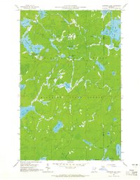
1960 Map of Kawishiwi Lake
USGS Topo · Published 1965About this map
Kawishiwi Lake and its surrounding network of waterways define this landscape in the early 1960s, straddling the border between Superior National Forest and Minnesota State Forest. The map documents a primitive wilderness character, where transportation is dictated by the connection of lakes like Phoebe Lake, Knight Lake, and Perent Lake via narrow channels and creeks. The presence of the Kawishiwi Lake Campground suggests the area's role as a gateway for recreation, while the intricate drainage systems of Hog Creek and Bone Creek illustrate the complex hydrology of the Boundary Waters region.
Find a feature on this map
35 named features on this map. Tap any name to fly to it.
Don’t see what you’re looking for? This feature index may not catch every label — zoom into the map to look around manually.
Map Details
Editions of this 1960 Kawishiwi Lake Map
3 editions found
Other maps of this area

1954 · Two Harbors
USGS Topo · 1:250,000

1955 · Tofte
USGS Topo · 1:62,500

1955 · Cramer
USGS Topo · 1:62,500

1957 · Two Harbors
USGS Topo · 1:250,000

1958 · Two Harbors
USGS Topo · 1:250,000

1960 · Lake Polly
USGS Topo · 1:24,000

1960 · Kawishiwi Lake
USGS Topo · 1:24,000

1960 · Perent Lake
USGS Topo · 1:24,000

1960 · Beth Lake
USGS Topo · 1:24,000
1960 · Kelso Mountain
USGS Topo · 1:24,000