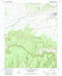
1968 Map of Kayenta West
USGS Topo · Published 1985About this map
The high desert community of Kayenta serves as a focal point within the northern reaches of the Navajo Indian Reservation during the late 1960s. This survey illustrates a landscape defined by significant elevation changes, from the heights of Tyende Mesa to the dramatic rim of Lolamai Point. The distribution of water sources is critical to the region, marked by numerous named points such as Little Shonto Spring, Fir Spring, and Tees Spa Spring.
Find a feature on this map
15 named features on this map. Tap any name to fly to it.
Don’t see what you’re looking for? This feature index may not catch every label — zoom into the map to look around manually.
Map Details
Editions of this 1968 Kayenta West Map
2 editions found
Other maps of this area

1883 · Marsh Pass
USGS Topo · 1:250,000

1892 · Marsh Pass
USGS Topo · 1:250,000

1952 · Agathla Peak 2 SW
USGS Topo · 1:24,000

1952 · Boot Mesa
USGS Topo · 1:62,500

1952 · Agathla Peak 2 SE
USGS Topo · 1:24,000

1952 · Agathla Peak
USGS Topo · 1:62,500

1952 · Agathla Peak 1 SW
USGS Topo · 1:24,000

1956 · Marble Canyon
USGS Topo · 1:250,000

1959 · Marble Canyon
USGS Topo · 1:250,000

1961 · Marble Canyon
USGS Topo · 1:250,000