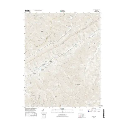
2016 Map of Kayjay
USGS Topo · Published 2016About this map
Pine Mountain and the Log Mountains dominate the landscape of the Cumberland Plateau along the Knox and Bell county line. This 2016 survey documents the complex topography and winding drainage systems that define the region, including the headwaters of Greasy Creek and Little Clear Creek. The settlement pattern follows the narrow valley floors, with small communities like Kayjay, Davisburg, and Chenoa situated between steep ridges and hollows. The presence of numerous family and community burial grounds, such as the Old Carroll Cem, Head Cem, and Fox Cem, provides a detailed record of local genealogy. Names like Cannel Coal Hollow and Furnace Branch reflect the industrial heritage of the area, while a network of rural routes like Kay Jay Camp road and the Davisburg Trail connect these remote Appalachian highlands.
Find a feature on this map
106 named features on this map. Tap any name to fly to it.
Don’t see what you’re looking for? This feature index may not catch every label — zoom into the map to look around manually.
Map Details
Editions of this 2016 Kayjay Map
This is the sole edition of this map. No revisions or reprints were ever made.
Other maps of this area

1886 · Cumberland Gap
USGS Topo · 1:125,000

1888 · Cumberland Gap
USGS Topo · 1:125,000

1891 · Cumberland Gap
USGS Topo · 1:125,000

1903 · Pineville
USGS Topo · 1:48,000

1903 · Middlesboro
USGS Topo · 1:48,000

1927 · Middlesboro
USGS Topo · 1:62,500

1930 · Middlesboro
USGS Topo · 1:62,500

1935 · Mingo Mountains
USGS Topo · 1:24,000

1935 · Cumberland Gap
USGS Topo · 1:24,000
1950 · Mingo Mountains
USGS Topo · 1:24,000