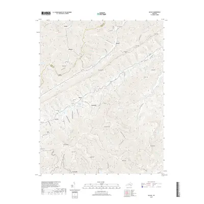
2019 Map of Kayjay
USGS Topo · Published 2019About this map
Log Mountains and the ridges of Pine Mountain dominate this corner of the Cumberland Plateau, where the boundary between Knox and Bell counties follows the high ground. The landscape is defined by its narrow hollows and numerous small cemeteries that serve the scattered mountain communities. In the north, Kayjay sits at the head of Brush Creek, while further south, the settlement of Chenoa is established near Bens Fork.
Find a feature on this map
98 named features on this map. Tap any name to fly to it.
Don’t see what you’re looking for? This feature index may not catch every label — zoom into the map to look around manually.
Map Details
Editions of this 2019 Kayjay Map
This is the sole edition of this map. No revisions or reprints were ever made.
Other maps of this area

1886 · Cumberland Gap
USGS Topo · 1:125,000

1888 · Cumberland Gap
USGS Topo · 1:125,000

1891 · Cumberland Gap
USGS Topo · 1:125,000

1903 · Pineville
USGS Topo · 1:48,000

1903 · Middlesboro
USGS Topo · 1:48,000

1927 · Middlesboro
USGS Topo · 1:62,500

1930 · Middlesboro
USGS Topo · 1:62,500

1935 · Mingo Mountains
USGS Topo · 1:24,000

1935 · Cumberland Gap
USGS Topo · 1:24,000
1950 · Mingo Mountains
USGS Topo · 1:24,000