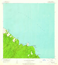
1957 Map of Keanae
USGS Topo · Published 1963About this map
Wailua and Keanae Uka anchor this coastal survey of Maui's windward shore, capturing the landscape as it appeared in the mid-1950s. The region is defined by the winding route of the Hana Highway as it traverses the deep gulches and steep ridges of the Koolau Forest Reserve. The map details the intricate irrigation and water management of the era, visible in the numerous streams like West Wailuaiki Stream and East Wailuaiki Stream that feed into the lush agricultural lands of the Wailua Homesteads. Along the coastline, distinctive geographical landmarks such as the Natural Arch near Pauwalu Pt and the enclosed Waialohe Pond highlight the interface between the volcanic terrain and the Pacific Ocean. Community life is centered around the Keanae School and the local Cem, providing a valuable record for genealogists studying these coastal settlements.
Find a feature on this map
46 named features on this map. Tap any name to fly to it.
Don’t see what you’re looking for? This feature index may not catch every label — zoom into the map to look around manually.
Map Details
Editions of this 1957 Keanae Map
2 editions found
Other maps of this area

1954 · Maui
USGS Topo · 1:250,000

1957 · Kilohana
USGS Topo · 1:24,000

1957 · Hana
USGS Topo · 1:24,000

1957 · Haiku
USGS Topo · 1:24,000

1957 · Nahiku
USGS Topo · 1:24,000

1957 · Keanae
USGS Topo · 1:24,000

1966 · Maui
USGS Topo · 1:250,000

1974 · Maui
USGS Topo · 1:250,000

1978 · Hana
USGS Topo · 1:24,000

1983 · Nahiku
USGS Topo · 1:24,000