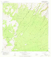
1956 Map of Keanakolu
USGS Topo · Published 1973About this map
The Doctor David Douglas Historical Monument (Kaluakauka) stands as a notable landmark in this upland landscape, marking the site where the famed Scottish botanist met his end. The terrain is defined by a dense network of forest reserves and homestead tracts, including the Hamakua Forest Reserve and Laupahoehoe Homesteads, which demonstrate the mid-century intersection of state conservation efforts and agricultural land divisions on the Big Island.
Find a feature on this map
49 named features on this map. Tap any name to fly to it.
Don’t see what you’re looking for? This feature index may not catch every label — zoom into the map to look around manually.
Map Details
Editions of this 1956 Keanakolu Map
2 editions found
Other maps of this area

1915 · Hamakua
USGS Topo · 1:62,500

1915 · Honomu
USGS Topo · 1:62,500

1954 · Hawaii North
USGS Topo · 1:250,000

1956 · Pua Akala
USGS Topo · 1:24,000

1956 · Keanakolu
USGS Topo · 1:24,000

1956 · Mauna Kea
USGS Topo · 1:24,000

1956 · Umikoa
USGS Topo · 1:24,000

1957 · Kukaiau
USGS Topo · 1:24,000

1957 · Honokaa
USGS Topo · 1:24,000

1959 · Hawaii North
USGS Topo · 1:250,000