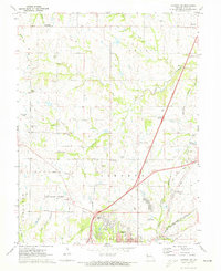
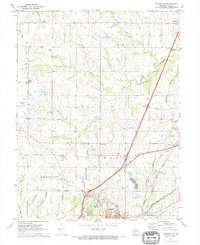
1971 Map of Kearney SW
USGS Topo · Published 1973About this map
Fishing River and its numerous tributaries, including Brushy Creek and Little Shoal Creek, carve a rolling landscape where the suburban expansion of Kansas City and Liberty meets established rural Clay County. The early 1970s marked a transition for this area, as newer developments like the Claycrest Golf Course and Bennett Park began to neighbor traditional landmarks. Long-standing family and community sites are well-represented, from the Old Providence Cem and Providence Ch to several small schools such as Walnut Grove Sch and St James Sch. The infrastructure of the era is defined by the Burlington Northern and the Chicago Rock Island and Pacific railroads, which helped sustain small hubs like Chandler and Roosterville before the full arrival of modern interstate corridors.
Find a feature on this map
55 named features on this map. Tap any name to fly to it.
Don’t see what you’re looking for? This feature index may not catch every label — zoom into the map to look around manually.
Map Details
Editions of this 1971 Kearney SW Map
2 editions found
Other maps of this area

1890 · Kansas City
USGS Topo · 1:125,000

1894 · Kansas City
USGS Topo · 1:125,000

1894 · Independence
USGS Topo · 1:125,000

1914 · Smithville
USGS Topo · 1:62,500
1935 · Missouri City
USGS Topo · 1:24,000

1935 · North Kansas City
USGS Topo · 1:24,000

1935 · Liberty
USGS Topo · 1:24,000

1936 · Kearney
USGS Topo · 1:48,000

1940 · Liberty
USGS Topo · 1:31,680

1940 · North Kansas City
USGS Topo · 1:31,680