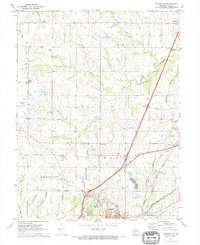
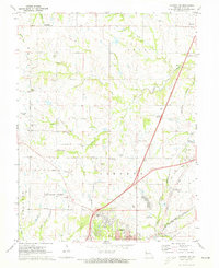
1971 Map of Kearney SW
USGS Topo · Published 1973About this map
Ectonville and the rural outskirts of Kansas City and Liberty define this Missouri landscape in the early 1970s. The area is characterized by a dense network of country cemeteries and small settlements, including Winner, Roosterville, and Chandler. The rolling terrain is drained by the Fishing River and its tributaries like Brushy Creek and Rock Creek, while the southern portion of the map shows the encroaching suburban grid of northern Kansas City, marked by NE 96th Street and Flintlock Road.
Find a feature on this map
54 named features on this map. Tap any name to fly to it.
Don’t see what you’re looking for? This feature index may not catch every label — zoom into the map to look around manually.
Map Details
Editions of this 1971 Kearney SW Map
2 editions found
Other maps of this area

1890 · Kansas City
USGS Topo · 1:125,000

1894 · Kansas City
USGS Topo · 1:125,000

1894 · Independence
USGS Topo · 1:125,000

1914 · Smithville
USGS Topo · 1:62,500
1935 · Missouri City
USGS Topo · 1:24,000

1935 · North Kansas City
USGS Topo · 1:24,000

1935 · Liberty
USGS Topo · 1:24,000

1936 · Kearney
USGS Topo · 1:48,000

1940 · Liberty
USGS Topo · 1:31,680

1940 · North Kansas City
USGS Topo · 1:31,680