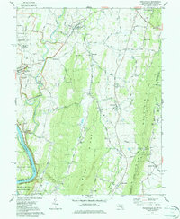
1978 Map of Keedysville
USGS Topo · Published 1979About this map
Antietam Creek meanders through a landscape defined by Civil War memory and a distinct ridge-and-valley topography in the late 1970s. The western edge of the map preserves the National Battlefield Site near Sharpsburg, featuring numerous memorials such as the Philadelphia Brigade Monument and the Hawkins Zouaves Monument. This area is a critical resource for genealogists and historians tracing the terrain of the 1862 conflict, with the Antietam Nat Cem and various family-named sites like Mumma Cem clearly marked.
Find a feature on this map
69 named features on this map. Tap any name to fly to it.
Don’t see what you’re looking for? This feature index may not catch every label — zoom into the map to look around manually.
Map Details
Editions of this 1978 Keedysville Map
4 editions found
Other maps of this area

1884 · Harpers Ferry
USGS Topo · 1:125,000

1891 · Harpers Ferry
USGS Topo · 1:125,000

1893 · Harpers Ferry
USGS Topo · 1:125,000

1908 · Middletown
USGS Topo · 1:48,000

1909 · Hagerstown
USGS Topo · 1:48,000

1910 · Antietam
USGS Topo · 1:62,500

1912 · Hagerstown
USGS Topo · 1:62,500

1912 · Williamsport
USGS Topo · 1:62,500

1914 · Martinsburg
USGS Topo · 1:48,000

1916 · Martinsburg
USGS Topo · 1:62,500