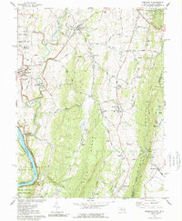
1978 Map of Keedysville
USGS Topo · Published 1989About this map
Antietam Nat Cem and the Philadelphia Brigade Monument sit along the western edge of this 1970s survey, marking the significant commemorative landscape of the National Battlefield Site. The terrain is defined by the steep ridges of South Mountain and Blue Ridge, which overlook the winding course of Antietam Creek and the southern flow of the Potomac River. The map provides a detailed view of the regional infrastructure of the era, from the historic Chesapeake and Ohio Canal to the active Baltimore and Ohio Railroad corridor near Rohersville. Smaller settlements such as Keedysville, Burkittsville, and Eakles Mills are visible, connected by a network of rural routes like Dog Street Road and Marble Quarry Road. The presence of the Appalachian Trail along the mountain crest underscores the area's transition toward recreational and historical preservation.
Find a feature on this map
87 named features on this map. Tap any name to fly to it.
Don’t see what you’re looking for? This feature index may not catch every label — zoom into the map to look around manually.
Map Details
Editions of this 1978 Keedysville Map
4 editions found
Other maps of this area

1884 · Harpers Ferry
USGS Topo · 1:125,000

1891 · Harpers Ferry
USGS Topo · 1:125,000

1893 · Harpers Ferry
USGS Topo · 1:125,000

1908 · Middletown
USGS Topo · 1:48,000

1909 · Hagerstown
USGS Topo · 1:48,000

1910 · Antietam
USGS Topo · 1:62,500

1912 · Hagerstown
USGS Topo · 1:62,500

1912 · Williamsport
USGS Topo · 1:62,500

1914 · Martinsburg
USGS Topo · 1:48,000

1916 · Martinsburg
USGS Topo · 1:62,500