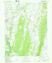
1978 Map of Keedysville
USGS Topo · Published 1978About this map
Antietam Nat Cem and the surrounding Battlefield Site dominate the western landscape of this Maryland and West Virginia border region. The 1970s terrain is marked by a legacy of memory, featuring several commemorative landmarks such as the Philadelphia Brigade Monument and the New York State Monument Visitor Center. To the east, the steep elevation of South Mountain is traversed by the Appalachian Trail, providing a sharp geographical contrast to the agricultural valleys and the winding course of Antietam Creek.
Find a feature on this map
108 named features on this map. Tap any name to fly to it.
Don’t see what you’re looking for? This feature index may not catch every label — zoom into the map to look around manually.
Map Details
Editions of this 1978 Keedysville Map
4 editions found
Other maps of this area

1884 · Harpers Ferry
USGS Topo · 1:125,000

1891 · Harpers Ferry
USGS Topo · 1:125,000

1893 · Harpers Ferry
USGS Topo · 1:125,000

1908 · Middletown
USGS Topo · 1:48,000

1909 · Hagerstown
USGS Topo · 1:48,000

1910 · Antietam
USGS Topo · 1:62,500

1912 · Hagerstown
USGS Topo · 1:62,500

1912 · Williamsport
USGS Topo · 1:62,500

1914 · Martinsburg
USGS Topo · 1:48,000

1916 · Martinsburg
USGS Topo · 1:62,500