
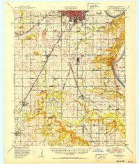
1950 Map of Keefeton
USGS Topo · Published 1950About this map
Rentiesville and Oktaha anchor the southern reaches of this mid-century Oklahoma landscape, where the agricultural plains are deeply etched by the winding course of the Arkansas River and Dirty Creek. The era's transportation network is remarkably dense, featuring the St Louis San Francisco railroad and the Midland Valley line, which served a landscape transitioning toward modernization as evidenced by Hatbox Field and the Municipal Airport. Genealogists will find an incredible density of rural social centers, including numerous family and community landmarks like Plainview Cem, Elm Grove Cem, and Mt Zion Ch and sch. These sites, along with a proliferation of district schools such as Sally Brown Sch and Sequoyah Sch, reveal the intricate fabric of township life before the consolidation of rural communities in the later 20th century.
Find a feature on this map
64 named features on this map. Tap any name to fly to it.
Don’t see what you’re looking for? This feature index may not catch every label — zoom into the map to look around manually.
Map Details
Editions of this 1950 Keefeton Map
2 editions found
Other maps of this area

1896 · Okmulgee
USGS Topo · 1:125,000

1900 · Sansbois
USGS Topo · 1:125,000

1900 · Canadian
USGS Topo · 1:125,000

1900 · Okmulgee
USGS Topo · 1:125,000

1901 · Muscogee
USGS Topo · 1:125,000

1905 · Muscogee
USGS Topo · 1:125,000

1909 · Sans Bois
USGS Topo · 1:125,000

1911 · Sansbois
USGS Topo · 1:125,000

1946 · Fort Smith
USGS Topo · 1:250,000

1948 · Hulbert
USGS Topo · 1:62,500