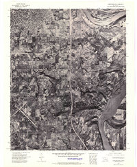
1972 Map of Keefeton NE
USGS Topo · Published 1974About this map
Muskogee sits at the northern edge of this orthophotomosaic, marking the transition from urban industrial development to the varied terrain of east-central Oklahoma. The imagery captures a critical geographic junction where the Arkansas River flows toward the extensive Webbers Falls Reservoir, a landscape reshaped by mid-century water management. To the south, the aviation infrastructure of Davis Field provides a clear landmark among the grid of rural roads and agricultural plots. The eastern portion of the sheet is dominated by the prominent rise of Brushy Mountain, whose shadowed slopes contrast sharply with the flat alluvial plains of the river valley. This 1972 survey offers a precise photographic record of the region's land use, showing the balance between city expansion and the natural contours of the river basin.
Find a feature on this map
5 named features on this map. Tap any name to fly to it.
Don’t see what you’re looking for? This feature index may not catch every label — zoom into the map to look around manually.
Map Details
Editions of this 1972 Keefeton NE Map
This is the sole edition of this map. No revisions or reprints were ever made.
Other maps of this area

1901 · Muscogee
USGS Topo · 1:125,000

1905 · Muscogee
USGS Topo · 1:125,000

1946 · Fort Smith
USGS Topo · 1:250,000

1948 · Hulbert
USGS Topo · 1:62,500

1948 · Keefeton
USGS Topo · 1:62,500

1948 · Webbers Falls
USGS Topo · 1:62,500

1948 · Wagoner
USGS Topo · 1:62,500

1950 · Keefeton
USGS Topo · 1:62,500

1950 · Wagoner
USGS Topo · 1:62,500

1950 · Hulbert
USGS Topo · 1:62,500