
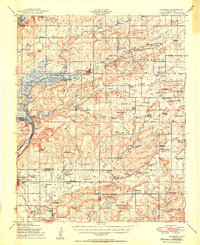
1950 Map of Hulbert
USGS Topo · Published 1950About this map
The construction of Gibson Reservoir defines the changing landscape of Cherokee County at mid-century, where the waters of Fourteen Mile Creek were being harnessed. Near the town of Hulbert, the map details a community dense with local landmarks such as New Hope Ch and Lost City. The southern portion of the sheet is dominated by the Camp Gruber Military Reservation, established during the war years, which transformed the area surrounding Oriental Village and Red Berry Mountain.
Find a feature on this map
104 named features on this map. Tap any name to fly to it.
Don’t see what you’re looking for? This feature index may not catch every label — zoom into the map to look around manually.
Map Details
Editions of this 1950 Hulbert Map
2 editions found
Other maps of this area

1896 · Pryor
USGS Topo · 1:125,000

1898 · Tahlequah
USGS Topo · 1:125,000

1899 · Siloam Springs
USGS Topo · 1:125,000

1901 · Muscogee
USGS Topo · 1:125,000

1901 · Pryor
USGS Topo · 1:125,000

1901 · Tahlequah
USGS Topo · 1:125,000

1903 · Siloam Springs
USGS Topo · 1:125,000

1904 · Siloam Springs
USGS Topo · 1:125,000

1905 · Muscogee
USGS Topo · 1:125,000

1905 · Tahlequah
USGS Topo · 1:125,000