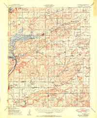
1950 Map of Hulbert
USGS Topo · Published 1950About this map
Hulbert sits at the heart of this post-war Oklahoma landscape, appearing just as the Fort Gibson Reservoir began to reshape the valley of Fourteen Mile Creek. The map records a transition from traditional land use to federal development, with the sprawling Camp Gruber Military Reservation dominating the southern half and the reservoir project actively under construction to the west. Rural life is still deeply etched into the hills, marked by a dense network of country institutions such as the Sequoyah Indian Sch, Strader Sch, and New Hope Ch.
Find a feature on this map
98 named features on this map. Tap any name to fly to it.
Don’t see what you’re looking for? This feature index may not catch every label — zoom into the map to look around manually.
Map Details
Editions of this 1950 Hulbert Map
2 editions found

Other maps of this area

1896 · Pryor
USGS Topo · 1:125,000

1898 · Tahlequah
USGS Topo · 1:125,000

1899 · Siloam Springs
USGS Topo · 1:125,000

1901 · Muscogee
USGS Topo · 1:125,000

1901 · Pryor
USGS Topo · 1:125,000

1901 · Tahlequah
USGS Topo · 1:125,000

1903 · Siloam Springs
USGS Topo · 1:125,000

1904 · Siloam Springs
USGS Topo · 1:125,000

1905 · Muscogee
USGS Topo · 1:125,000

1905 · Tahlequah
USGS Topo · 1:125,000