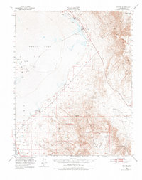
1951 Map of Keeler
USGS Topo · Published 1974About this map
The eastern shore of Owens Lake and the industrial activity of the early 1950s define this survey of the High Desert. The settlement of Keeler serves as a hub for extraction, connected by the Southern Pacific railroad and a long-distance Tramway stretching into the Inyo Mountains. Evident throughout the basin are the footprints of salt and mineral processing, from the Soda Products Plant and Soda Evaporators to various Salt Wells scattered along the lakebed.
Find a feature on this map
27 named features on this map. Tap any name to fly to it.
Don’t see what you’re looking for? This feature index may not catch every label — zoom into the map to look around manually.
Map Details
Editions of this 1951 Keeler Map
4 editions found

Other maps of this area

1905 · Olancha
USGS Topo · 1:125,000

1907 · Olancha
USGS Topo · 1:125,000

1907 · Mt. Whitney
USGS Topo · 1:125,000

1908 · Ballarat
USGS Topo · 1:250,000

1913 · Ballarat
USGS Topo · 1:250,000

1919 · Mt. Whitney
USGS Topo · 1:125,000

1937 · Mt. Whitney
USGS Topo · 1:125,000

1948 · Death Valley
USGS Topo · 1:250,000

1948 · Fresno
USGS Topo · 1:250,000

1950 · Darwin
USGS Topo · 1:62,500