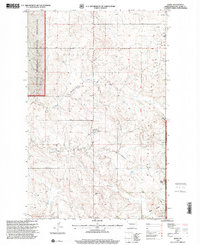
1997 Map of Keene
USGS Topo · Published 2001About this map
Keene serves as a central point in this northern McKenzie County landscape, where the agricultural plains meet the industrial footprint of the Blue Butte Oil and Gas Field. The map reveals a community defined by its spiritual and civic institutions, with the Clear Creek Ch and its adjacent Cem, Redeemer Ch, and Adventist Ch scattered across the township. This late-twentieth-century survey documents the transition from traditional ranching to an energy-producing economy, evidenced by the presence of Amerada Hess Offices and multiple Scoria Pits. The rugged western edge is marked by the Little Missouri National Grassland, while the topography is drained by Clear Creek and its North Branch. The Fourteenth Guide Meridian West provides a formal surveying baseline through a terrain characterized by prominent landmarks like Stony Butte and the Blue Buttes.
Find a feature on this map
16 named features on this map. Tap any name to fly to it.
Don’t see what you’re looking for? This feature index may not catch every label — zoom into the map to look around manually.
Map Details
Editions of this 1997 Keene Map
This is the sole edition of this map. No revisions or reprints were ever made.
Other maps of this area

1911 · Ray
USGS Topo · 1:125,000

1953 · Williston
USGS Topo · 1:250,000

1953 · Watford City
USGS Topo · 1:250,000

1957 · Williston
USGS Topo · 1:250,000

1957 · Watford City
USGS Topo · 1:250,000

1965 · Keene
USGS Topo · 1:24,000

1965 · Johnsons Corner
USGS Topo · 1:24,000

1965 · Charlson
USGS Topo · 1:24,000

1965 · Blue Buttes
USGS Topo · 1:24,000

1965 · Charlson SW
USGS Topo · 1:24,000