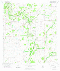
1956 Map of Keentown
USGS Topo · Published 1973About this map
The North Fork Manatee River and South Fork Little Manatee River define this rural landscape of eastern Manatee County. Established settlements are sparse, centered primarily around Keentown and the elevation of Bunker Hill, where the Bunker Hill Ch stands as a community landmark. The terrain is a network of watercourses and wetlands, with names like Graveyard Creek, Gilley Creek, and Peacock Br draining the low-lying hammocks.
Find a feature on this map
16 named features on this map. Tap any name to fly to it.
Don’t see what you’re looking for? This feature index may not catch every label — zoom into the map to look around manually.
Map Details
Editions of this 1956 Keentown Map
3 editions found

Other maps of this area

1944 · Rye
USGS Topo · 1:31,680

1944 · Wimauma
USGS Topo · 1:31,680

1944 · Verna
USGS Topo · 1:31,680

1947 · Wimauma
USGS Topo · 1:25,000

1956 · Myakka City NW
USGS Topo · 1:24,000

1956 · Ft Lonesome
USGS Topo · 1:24,000

1956 · Myakka Head
USGS Topo · 1:24,000

1956 · Duette NE
USGS Topo · 1:24,000
1956 · Wimauma
USGS Topo · 1:24,000

1956 · Duette
USGS Topo · 1:24,000