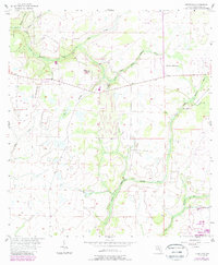
1956 Map of Keentown
USGS Topo · Published 1987About this map
Bunker Hill rises above the rural landscape of Manatee County, marking a terrain of winding waterways and remote landmarks as they appeared in the mid-1950s. The settlement of Keentown is situated near the confluence of Peacock Br and the North Fork Little Manatee River, a region defined by the intricate drainage patterns of Gravelly Creek and Long Branch. Local history is anchored by the Bunker Hill Ch and the nearby Keen Cem, which reflect the early community structure of this inland Florida territory. The map illustrates a transitional period where traditional landmarks like Peacock Hammock coexist with newer developments such as a Substation and a remote Landing Strip, showing the slow integration of utility infrastructure into the cattle and citrus lands before the major suburban expansions of the late 20th century.
Find a feature on this map
22 named features on this map. Tap any name to fly to it.
Don’t see what you’re looking for? This feature index may not catch every label — zoom into the map to look around manually.
Map Details
Editions of this 1956 Keentown Map
3 editions found

Other maps of this area

1944 · Rye
USGS Topo · 1:31,680

1944 · Wimauma
USGS Topo · 1:31,680

1944 · Verna
USGS Topo · 1:31,680

1947 · Wimauma
USGS Topo · 1:25,000

1956 · Myakka City NW
USGS Topo · 1:24,000

1956 · Ft Lonesome
USGS Topo · 1:24,000

1956 · Myakka Head
USGS Topo · 1:24,000

1956 · Duette NE
USGS Topo · 1:24,000
1956 · Wimauma
USGS Topo · 1:24,000

1956 · Duette
USGS Topo · 1:24,000