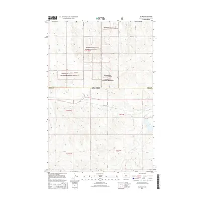
2015 Map of Keldron
USGS Topo · Published 2015About this map
Keldron sits at the heart of this landscape along the border of North Dakota and South Dakota, a small settlement situated just south of the Beaverhead National Forest Cedar River National Grassland. The terrain is defined by the winding course of Hay Cr, which flows eastward toward Morristown Lake near the edge of the quadrangle. This 2015 survey reveals a sparse road network of township and county routes, such as Cr-33 and 215th Ave, which connect isolated farmsteads across the rolling plains. The intersection of state and county boundaries, including the line between North Dakota and South Dakota and Sioux and Corson counties, underscores the area's identity as a borderland where public grazing lands meet private agricultural holdings.
Find a feature on this map
27 named features on this map. Tap any name to fly to it.
Don’t see what you’re looking for? This feature index may not catch every label — zoom into the map to look around manually.
Map Details
Editions of this 2015 Keldron Map
This is the sole edition of this map. No revisions or reprints were ever made.
Other maps of this area

1953 · McIntosh
USGS Topo · 1:250,000

1954 · Bismarck
USGS Topo · 1:250,000

1958 · Bismarck
USGS Topo · 1:250,000

1958 · McIntosh
USGS Topo · 1:250,000

1972 · Morristown
USGS Topo · 1:24,000

1972 · Pretty Rock Butte SE
USGS Topo · 1:24,000

1972 · Round Top
USGS Topo · 1:24,000

1972 · Skull Butte
USGS Topo · 1:24,000

1972 · Thunder Hawk SW
USGS Topo · 1:24,000

1972 · Thunder Hawk SE
USGS Topo · 1:24,000
Featured Places
- Menz Township, Porcupine District
- Keldron, Rock Creek District
- Porcupine District, ND
- Rock Creek District, SD
- Sioux County, ND