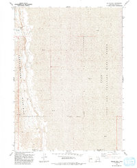
1991 Map of Keller Well
USGS Topo · Published 1991About this map
Newfoundland Mountains rise sharply out of the vast Mud flats of the Great Salt Lake Desert in this 1991 revision. The landscape is defined by the stark contrast between the steep, topographic complexity of South Newfoundland and the expansive, featureless alkali plains to the east. Human presence is sparse, centered on the utilitarian outpost of Keller Well, which features isolated Storage Bins at the foot of the range. Much of the eastern half of the map is designated as a Military Reservation, part of the Utah Test and Training Range, where the county line between Box Elder Co and Tooele Co cuts across the barren flats. The map documents a specialized environment where isolation and terrain dictated land use for defense and minimal grazing.
Find a feature on this map
8 named features on this map. Tap any name to fly to it.
Don’t see what you’re looking for? This feature index may not catch every label — zoom into the map to look around manually.
Map Details
Editions of this 1991 Keller Well Map
This is the sole edition of this map. No revisions or reprints were ever made.
Other maps of this area

1953 · Tooele
USGS Topo · 1:250,000

1954 · Brigham City
USGS Topo · 1:250,000

1955 · Tooele
USGS Topo · 1:250,000

1958 · Brigham City
USGS Topo · 1:250,000

1962 · Brigham City
USGS Topo · 1:250,000

1973 · Knolls 2 NW
USGS Topo · 1:24,000

1973 · Knolls 2 NE
USGS Topo · 1:24,000

1973 · Finger Ridge
USGS Topo · 1:24,000
1979 · Bonneville Salt Flats
USGS Topo · 1:100,000

1983 · Desert Peak
USGS Topo · 1:24,000