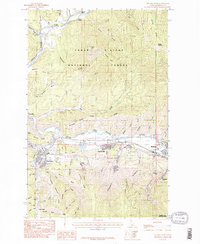
1985 Map of Kellogg West
USGS Topo · Published 1985About this map
Kellogg and its neighboring mining-era settlements sit at the heart of this mid-1980s Shoshone County landscape, where the South Fork Coeur D'alene River corridor dictates the region's industrial and residential layout. The map documents a complex landscape of heavy industry and natural forest, notably featuring extensive tailings areas near Smelterville and the deep incisions of Government Gulch. These industrial features contrast with the sprawling Coeur D'Alene National Forest that dominates the northern and southern elevations. Local infrastructure such as the Shoshone County Airport, a Rodeo Ground, and the local golf course are mapped alongside numerous small drainages like Milo Creek and Jackass Creek. This survey records the late-century footprint of the Silver Valley, from the residential streets of Pinehurst to the high points of Haystack Peak and Fubar Peak.
Find a feature on this map
63 named features on this map. Tap any name to fly to it.
Don’t see what you’re looking for? This feature index may not catch every label — zoom into the map to look around manually.
Map Details
Editions of this 1985 Kellogg West Map
2 editions found
Other maps of this area

1901 · Coeur D'Alene District
USGS Topo · 1:62,500

1903 · Coeur D'Alene District
USGS Topo · 1:62,500

1906 · Coeur D'Alene District
USGS Topo · 1:62,500

1909 · Cataldo
USGS Topo · 1:125,000

1911 · Cataldo
USGS Topo · 1:125,000

1950 · Twin Crags
USGS Topo · 1:24,000

1952 · Twin Crags
USGS Topo · 1:24,000

1955 · Spokane
USGS Topo · 1:250,000

1957 · Kingston
USGS Topo · 1:62,500

1957 · Kellogg
USGS Topo · 1:62,500