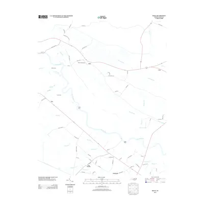
2013 Map of Kelly
USGS Topo · Published 2013About this map
The Cape Fear River dominates this Bladen County landscape, winding past historical riverfront markers like Locks Point, Grays Point, and Kings Bluff. The settlement pattern follows the high ground and early transportation corridors, with the rural communities of East Arcadia, Kelly, and Sandyfield serving as the primary population centers. The presence of Elwells Ferry highlights the enduring importance of river crossings in this region of North Carolina, while the Mitchell Field Airport marks a modern utility in an otherwise agricultural and swamp-adjacent setting.
Find a feature on this map
65 named features on this map. Tap any name to fly to it.
Don’t see what you’re looking for? This feature index may not catch every label — zoom into the map to look around manually.
Map Details
Editions of this 2013 Kelly Map
This is the sole edition of this map. No revisions or reprints were ever made.
Other maps of this area

1953 · Florence
USGS Topo · 1:250,000

1954 · Florence
USGS Topo · 1:250,000

1954 · White Lake
USGS Topo · 1:62,500

1954 · Acme
USGS Topo · 1:62,500

1954 · Bolton
USGS Topo · 1:62,500

1955 · Atkinson
USGS Topo · 1:62,500
1980 · Acme
USGS Topo · 1:24,000
1980 · Point Caswell
USGS Topo · 1:24,000

1982 · Elizabethtown
USGS Topo · 1:100,000
1983 · Point Caswell
USGS Topo · 1:24,000