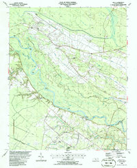
1986 Map of Kelly
USGS Topo · Published 1986About this map
The Cape Fear River dominates this mid-1980s landscape, winding past Locks Point and Grays Point in a series of dramatic bends. Along its northern banks, the settlement of Kelly serves as a local hub, connected to the southern riverbank by the historic Elwells Ferry. The area is characterized by an extensive network of drainage and transport infrastructure, including the Lyon Swamp Canal, the White Oak Canal, and the Seaboard railroad line.
Find a feature on this map
51 named features on this map. Tap any name to fly to it.
Don’t see what you’re looking for? This feature index may not catch every label — zoom into the map to look around manually.
Map Details
Editions of this 1986 Kelly Map
This is the sole edition of this map. No revisions or reprints were ever made.
Other maps of this area

1953 · Florence
USGS Topo · 1:250,000

1954 · Florence
USGS Topo · 1:250,000

1954 · White Lake
USGS Topo · 1:62,500

1954 · Acme
USGS Topo · 1:62,500

1954 · Bolton
USGS Topo · 1:62,500

1955 · Atkinson
USGS Topo · 1:62,500
1980 · Acme
USGS Topo · 1:24,000
1980 · Point Caswell
USGS Topo · 1:24,000

1982 · Elizabethtown
USGS Topo · 1:100,000
1983 · Point Caswell
USGS Topo · 1:24,000