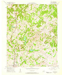
1957 Map of Kelly
USGS Topo · Published 1958About this map
The northern reaches of Hopkinsville transition into a landscape defined by small farming communities and winding watercourses in the mid-1950s. The Louisville and Nashville railroad serves as a primary north-south corridor, passing through the settlement of Kelly. This era is characterized by a dense network of rural landmarks, where community life centered around several country churches such as New Zion Ch and Blooming Grove Ch.
Find a feature on this map
31 named features on this map. Tap any name to fly to it.
Don’t see what you’re looking for? This feature index may not catch every label — zoom into the map to look around manually.
Map Details
Editions of this 1957 Kelly Map
This is the sole edition of this map. No revisions or reprints were ever made.
Other maps of this area

1909 · Dawson Springs
USGS Topo · 1:48,000

1911 · Dawson Springs
USGS Topo · 1:62,500

1912 · Nortonville
USGS Topo · 1:62,500

1950 · Pembroke
USGS Topo · 1:24,000

1951 · Pembroke
USGS Topo · 1:24,000

1951 · Church Hill
USGS Topo · 1:24,000

1951 · Hopkinsville
USGS Topo · 1:24,000

1952 · Pleasant Green Hill
USGS Topo · 1:24,000

1952 · Kelly
USGS Topo · 1:24,000

1952 · Honey Grove
USGS Topo · 1:24,000