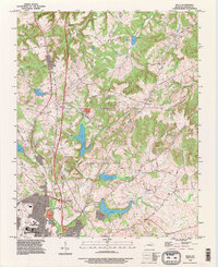
1993 Map of Kelly
USGS Topo · Published 1996About this map
The Pennyrile Parkway and Madisonville Road serve as the primary north-south corridors through this section of Christian County, where the transition from rural farmland to the northern outskirts of Hopkinsville is clearly visible. The landscape is defined by a series of significant reservoirs, including Lake Boxley, Lake Tandy, Morris Lake, and Buntin Lake, which are fed by the Middle Branch and Upper Branch drainages. These water bodies characterize the local topography alongside Mill Hill, providing a distinct contrast to the more developed southern portion of the quadrangle.
Find a feature on this map
40 named features on this map. Tap any name to fly to it.
Don’t see what you’re looking for? This feature index may not catch every label — zoom into the map to look around manually.
Map Details
Editions of this 1993 Kelly Map
This is the sole edition of this map. No revisions or reprints were ever made.
Other maps of this area

1909 · Dawson Springs
USGS Topo · 1:48,000

1911 · Dawson Springs
USGS Topo · 1:62,500

1912 · Nortonville
USGS Topo · 1:62,500

1950 · Pembroke
USGS Topo · 1:24,000

1951 · Pembroke
USGS Topo · 1:24,000

1951 · Church Hill
USGS Topo · 1:24,000

1951 · Hopkinsville
USGS Topo · 1:24,000

1952 · Pleasant Green Hill
USGS Topo · 1:24,000

1952 · Kelly
USGS Topo · 1:24,000

1952 · Honey Grove
USGS Topo · 1:24,000