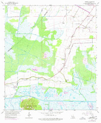
1963 Map of Kemper
USGS Topo · Published 1978About this map
Cote Blanche Island rises above the surrounding marshes and bayous of St. Mary Parish, providing a stark topographical contrast to the low-lying coastal plains. This 1960s landscape is defined by an intricate network of drainage and transportation, where the Intracoastal Waterway cuts through the southern reaches and the Southern Pacific railroad links small agricultural communities. The map documents a transition from plantation-era heritage to modern industrial infrastructure, evidenced by the proximity of the Kilgore Plantation and Home Place to newer developments like the Power Plant and various pipelines.
Find a feature on this map
39 named features on this map. Tap any name to fly to it.
Don’t see what you’re looking for? This feature index may not catch every label — zoom into the map to look around manually.
Map Details
Editions of this 1963 Kemper Map
2 editions found
Other maps of this area

1937 · Bayou Sale
USGS Topo · 1:62,500

1937 · Jeanerette
USGS Topo · 1:62,500

1937 · Derouen
USGS Topo · 1:62,500

1945 · New Orleans
USGS Topo · 1:250,000

1949 · Cypremort Pt
USGS Topo · 1:31,680

1954 · Jeanerette
USGS Topo · 1:62,500

1957 · Bayou Sale
USGS Topo · 1:62,500

1963 · New Orleans
USGS Topo · 1:250,000
1963 · Weeks
USGS Topo · 1:24,000
1963 · Charenton
USGS Topo · 1:24,000