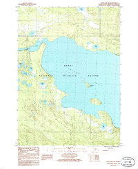
1986 Map of Kenai B-2 NE
USGS Topo · Published 1986About this map
Skilak Lake dominates this mid-1980s topographic study of the central Kenai Peninsula, showcasing a landscape managed for conservation and wilderness preservation. This region is defined by its complex aquatic network, where the Kenai River flows through the Kenai National Wildlife Refuge. The map details a transition from the expansive open water of the lake to the densely pocketed wetlands of the Kenai Wilderness to the south. Small, distinctive water bodies like Frisbee Lake and Fire Lake dot the glacial terrain, while human activity is restricted to specific points of infrastructure including a Guard Station, a Heliport, and a Campground. The presence of a Cabin and the Kenai Wilderness Boundary highlights the intersection of public land management and the preserved natural environment during this era of Alaskan land administration.
Find a feature on this map
18 named features on this map. Tap any name to fly to it.
Don’t see what you’re looking for? This feature index may not catch every label — zoom into the map to look around manually.
Map Details
Editions of this 1986 Kenai B-2 NE Map
This is the sole edition of this map. No revisions or reprints were ever made.
Other maps of this area

1944 · Kenai
USGS Topo · 1:250,000

1950 · Kenai
USGS Topo · 1:250,000

1950 · Kenai B-1
USGS Topo · 1:63,360

1951 · Kenai B-2
USGS Topo · 1:63,360

1951 · Kenai C-1
USGS Topo · 1:63,360

1951 · Kenai C-2
USGS Topo · 1:63,360

1952 · Kenai C-1
USGS Topo · 1:63,360

1952 · Kenai C-2
USGS Topo · 1:63,360

1952 · Kenai B-2
USGS Topo · 1:63,360

1952 · Kenai B-1
USGS Topo · 1:63,360