
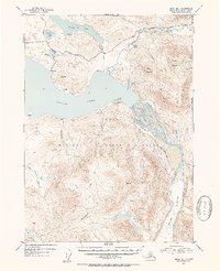
1952 Map of Kenai B-1
USGS Topo · Published 1954About this map
Stetters Ranch and a handful of isolated cabins provide the primary human traces in this early 1950s survey of the Kenai Peninsula. The landscape is defined by the massive Skilak Lake, which dominates the central portion of the map, and the braided channels of the Skilak River that flow from the Skilak Glacier to the southeast. Much of the territory falls within the Kenai National Moose Range, characterized by significant elevation changes between water level and peaks like Bear Mountain and Russian Mountain. Transportation in this era was focused along the Sterling Highway and the Sevenmile Trail, while a ferry crossing at the river's upper reaches provided essential access. Local hydrologic features such as Hidden Lake, Engineer Lake, and the small Alcatraz Lake dot the forested lowlands near the established campground.
Find a feature on this map
30 named features on this map. Tap any name to fly to it.
Don’t see what you’re looking for? This feature index may not catch every label — zoom into the map to look around manually.
Map Details
Editions of this 1952 Kenai B-1 Map
2 editions found
Other maps of this area

1944 · Kenai
USGS Topo · 1:250,000

1950 · Kenai
USGS Topo · 1:250,000

1950 · Kenai B-1
USGS Topo · 1:63,360

1950 · Seward A-8
USGS Topo · 1:63,360

1951 · Seward
USGS Topo · 1:250,000

1951 · Kenai B-2
USGS Topo · 1:63,360

1951 · Kenai C-1
USGS Topo · 1:63,360

1951 · Kenai C-2
USGS Topo · 1:63,360

1951 · Kenai A-2
USGS Topo · 1:63,360

1951 · Kenai A-1
USGS Topo · 1:63,360