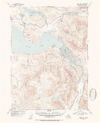
1952 Map of Kenai B-1
USGS Topo · Published 1954About this map
Kenai National Moose Range dominates this portion of the peninsula, illustrating a landscape managed for conservation in the early 1950s. The northern reaches show the emerging infrastructure of the era, centered around the Sterling Highway and the Seven Mile Trail. Local habitation is sparse, marked primarily by scattered cabins and the Shelters Ranch situated near the Kenai River. The map captures a complex hydrological network where the Skilak Glacier feeds the Skilak River, which in turn flows into the expansive Skilak Lake. Unique geographical features like the Irish Channel near Lucas Island and the isolated Twin Lakes in the southern highlands highlight the glacial character of the terrain. This survey provides an essential look at the Kenai wilderness before modern development altered its accessibility.
Find a feature on this map
32 named features on this map. Tap any name to fly to it.
Don’t see what you’re looking for? This feature index may not catch every label — zoom into the map to look around manually.
Map Details
Editions of this 1952 Kenai B-1 Map
2 editions found

Other maps of this area

1944 · Kenai
USGS Topo · 1:250,000

1950 · Kenai
USGS Topo · 1:250,000

1950 · Kenai B-1
USGS Topo · 1:63,360

1950 · Seward A-8
USGS Topo · 1:63,360

1951 · Seward
USGS Topo · 1:250,000

1951 · Kenai B-2
USGS Topo · 1:63,360

1951 · Kenai C-1
USGS Topo · 1:63,360

1951 · Kenai C-2
USGS Topo · 1:63,360

1951 · Kenai A-2
USGS Topo · 1:63,360

1951 · Kenai A-1
USGS Topo · 1:63,360