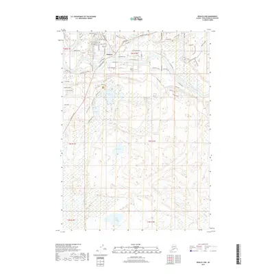
2018 Map of Kenai B-3 NW
USGS Topo · Published 2018About this map
Soldotna serves as the focal point of this Kenai Peninsula study, situated at the strategic junction of the Sterling Highway and the Kenai River. The 2018 survey detail captures the residential expansion of the city through a dense network of local roads including Redout Avenue, Marydale Ave, and Corral Avenue. South of the urban center, the landscape transitions into a complex of glacial water bodies and wetlands, characterized by Headquarters Lake, Slikok Lake, and the smaller Nordic Lake. The Soldotna Airport occupies a prominent position on the northern bank of the river, highlighting the importance of aviation infrastructure in this Alaskan corridor. Along the river's winding path, numerous named access points like River Park Drive and Swiftwater Park Road illustrate the community's orientation toward the water, while the southern reaches remain dominated by the natural drainage of Slikok Cr and the secluded Coal Creek Lake.
Find a feature on this map
76 named features on this map. Tap any name to fly to it.
Don’t see what you’re looking for? This feature index may not catch every label — zoom into the map to look around manually.
Map Details
Editions of this 2018 Kenai B-3 NW Map
This is the sole edition of this map. No revisions or reprints were ever made.
Other maps of this area

1944 · Kenai
USGS Topo · 1:250,000

1950 · Kenai
USGS Topo · 1:250,000

1950 · Kenai C-3
USGS Topo · 1:63,360

1950 · Kenai B-3
USGS Topo · 1:63,360

1951 · Kenai C-4
USGS Topo · 1:63,360

1951 · Kenai C-3
USGS Topo · 1:63,360

1951 · Kenai B-4
USGS Topo · 1:63,360

1952 · Kenai B-3
USGS Topo · 1:63,360

1952 · Kenai C-4
USGS Topo · 1:63,360
1952 · Kenai C-3
USGS Topo · 1:63,360