
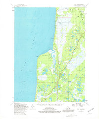
1951 Map of Kenai B-4
USGS Topo · Published 1967About this map
The Kasilof River winds its way toward Cook Inlet, defining the landscape of this mid-century coastal survey. Small settlements such as Kalifonsky and Cohoe reflect the early development of the region, anchored by the construction of the Sterling Highway. The area is characterized by a complex network of wetlands and glacial lakes, including Upper Cohoe Lake and Lower Cohoe Lake, which border the expansive Kenai National Moose Range.
Find a feature on this map
30 named features on this map. Tap any name to fly to it.
Don’t see what you’re looking for? This feature index may not catch every label — zoom into the map to look around manually.
Map Details
Editions of this 1951 Kenai B-4 Map
2 editions found
Other maps of this area

1944 · Kenai
USGS Topo · 1:250,000

1950 · Kenai
USGS Topo · 1:250,000

1950 · Kenai C-3
USGS Topo · 1:63,360

1950 · Kenai B-3
USGS Topo · 1:63,360

1951 · Kenai A-5
USGS Topo · 1:63,360

1951 · Kenai A-3
USGS Topo · 1:63,360

1951 · Kenai C-4
USGS Topo · 1:63,360

1951 · Kenai C-3
USGS Topo · 1:63,360

1951 · Kenai A-4
USGS Topo · 1:63,360

1952 · Kenai B-3
USGS Topo · 1:63,360