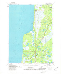
1951 Map of Kenai B-4
USGS Topo · Published 1981About this map
The Kasilof River carves a deep path through this coastal landscape as it flows toward Cook Inlet, anchoring a region of burgeoning energy and infrastructure in the mid-20th century. While much of the eastern terrain is protected within the Kenai National Moose Range, the western shore reflects active development along Kalifonsky Beach Road and the Sterling Highway. Numerous Gas Wells and a Pipeline highlight the area's industrial importance, contrasting with the scattered residential clusters near Cohoe and Kalifonsky.
Find a feature on this map
43 named features on this map. Tap any name to fly to it.
Don’t see what you’re looking for? This feature index may not catch every label — zoom into the map to look around manually.
Map Details
Editions of this 1951 Kenai B-4 Map
2 editions found
Other maps of this area

1944 · Kenai
USGS Topo · 1:250,000

1950 · Kenai
USGS Topo · 1:250,000

1950 · Kenai C-3
USGS Topo · 1:63,360

1950 · Kenai B-3
USGS Topo · 1:63,360

1951 · Kenai A-5
USGS Topo · 1:63,360

1951 · Kenai A-3
USGS Topo · 1:63,360

1951 · Kenai C-4
USGS Topo · 1:63,360

1951 · Kenai C-3
USGS Topo · 1:63,360

1951 · Kenai B-4
USGS Topo · 1:63,360

1951 · Kenai A-4
USGS Topo · 1:63,360