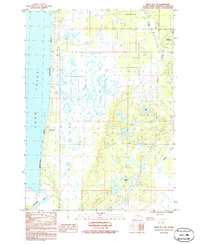
1986 Map of Kenai B-4 NE
USGS Topo · Published 1986About this map
The Kasilof River winds through the southern reaches of this peninsula landscape, where the waters of Cook Inlet meet the sandy expanse of Kalifornsky Beach. The 1980s economy is visibly tied to the land's resources, evidenced by the numerous Gas Wells and Gas Well sites dotting the interior, connected by a prominent Pipeline and a network of gravel pits. The settlement at Soldotna sits at the northeastern corner, while the coastal village of Kalifornsky provides a hub for maritime activity.
Find a feature on this map
21 named features on this map. Tap any name to fly to it.
Don’t see what you’re looking for? This feature index may not catch every label — zoom into the map to look around manually.
Map Details
Editions of this 1986 Kenai B-4 NE Map
This is the sole edition of this map. No revisions or reprints were ever made.
Other maps of this area

1944 · Kenai
USGS Topo · 1:250,000

1950 · Kenai
USGS Topo · 1:250,000

1950 · Kenai C-3
USGS Topo · 1:63,360

1950 · Kenai B-3
USGS Topo · 1:63,360

1951 · Kenai C-4
USGS Topo · 1:63,360

1951 · Kenai C-3
USGS Topo · 1:63,360

1951 · Kenai B-4
USGS Topo · 1:63,360

1952 · Kenai B-3
USGS Topo · 1:63,360

1952 · Kenai C-4
USGS Topo · 1:63,360
1952 · Kenai C-3
USGS Topo · 1:63,360