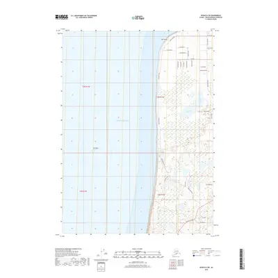
2018 Map of Kenai B-4 SW
USGS Topo · Published 2018About this map
Cape Kasilof and the surrounding coastline along the Pacific Ocean define this portion of the Kenai Peninsula. The landscape transition from the shoreline to the inland interior is marked by a network of local roads and residential corridors. Central to the inland area are Upper Cohoe Lake and Lower Cohoe Lake, which anchor the surrounding hydrology. Transportation in this part of the peninsula is dominated by the Cohoe Loop Road, which weaves through several small neighborhoods, and the Sterling Highway near the southern edge of the quadrangle. The map also identifies the offshore feature known as The Sisters, located west of the main coastline. These roads and water bodies reveal a pattern of residential growth and access to the natural resources of the Alaskan coast during the early 21st century.
Find a feature on this map
32 named features on this map. Tap any name to fly to it.
Don’t see what you’re looking for? This feature index may not catch every label — zoom into the map to look around manually.
Map Details
Editions of this 2018 Kenai B-4 SW Map
This is the sole edition of this map. No revisions or reprints were ever made.
Other maps of this area

1944 · Kenai
USGS Topo · 1:250,000

1950 · Kenai
USGS Topo · 1:250,000

1951 · Kenai A-5
USGS Topo · 1:63,360

1951 · Kenai B-4
USGS Topo · 1:63,360

1951 · Kenai A-4
USGS Topo · 1:63,360

1952 · Kenai A-5
USGS Topo · 1:63,360

1952 · Kenai B-4
USGS Topo · 1:63,360

1952 · Kenai A-4
USGS Topo · 1:63,360

1958 · Kenai
USGS Topo · 1:250,000
1986 · Kenai B-4 NW
USGS Topo · 1:25,000