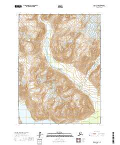
2017 Map of Kenai B-8 NW
USGS Topo · Published 2017About this map
Lake Clark National Park encompasses the majority of this Alaskan wilderness during the early 21st century. The landscape is defined by the high-elevation drainage of the North Fork Crescent River, which flows through a deeply carved valley toward the southwest. The topographic detail illustrates a high-relief environment where glacial-fed waters move from steep peaks into the broader basin of Crescent Lake at the southern edge of the survey area. This portion of the Kenai Peninsula remains largely untouched by development, showing no roads or established structures. The map provides a clear record of the glacial hydrology and land management boundaries within the national park system, specifically capturing the transition from alpine headwaters to lowland lake systems in a region accessible only by air or water.
Find a feature on this map
9 named features on this map. Tap any name to fly to it.
Don’t see what you’re looking for? This feature index may not catch every label — zoom into the map to look around manually.
Map Details
Editions of this 2017 Kenai B-8 NW Map
This is the sole edition of this map. No revisions or reprints were ever made.
Other maps of this area

1944 · Kenai
USGS Topo · 1:250,000

1946 · Lake Clark
USGS Topo · 1:250,000

1950 · Kenai
USGS Topo · 1:250,000

1951 · Lake Clark
USGS Topo · 1:250,000

1958 · Lake Clark B-1
USGS Topo · 1:63,360

1958 · Kenai B-8
USGS Topo · 1:63,360

1958 · Kenai C-8
USGS Topo · 1:63,360
1958 · Lake Clark C-1
USGS Topo · 1:63,360

1958 · Lake Clark
USGS Topo · 1:250,000

1958 · Kenai
USGS Topo · 1:250,000