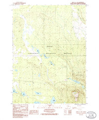
1986 Map of Kenai C-1 SW
USGS Topo · Published 1986About this map
The Kenai National Wildlife Refuge dominates this landscape, showing a complex network of glacial lakes and northern watercourses in the mid-1980s. A significant portion of the eastern sector is designated as the Kenai Wilderness, marked by a formal Wilderness Boundary that separates the more accessible terrain from the protected backcountry. Large water bodies like Hidden Lake and Upper Jean Lake are prominent features, while smaller, descriptively named lakes such as Picnic Lake, Campsite Lake, and Hikers Lake suggest the area's established role in recreation and outdoor transit. Utility corridors also cross the region, evidenced by a Pipeline and a Trans Line, indicating the intersection of wilderness preservation and energy infrastructure. Low-lying elevations like Hideout Hill rise above the drainage basins of Mystery Creek and Jean Creek, providing a detailed look at the peninsula's hydrography before modern shifts in the subarctic environment.
Find a feature on this map
19 named features on this map. Tap any name to fly to it.
Don’t see what you’re looking for? This feature index may not catch every label — zoom into the map to look around manually.
Map Details
Editions of this 1986 Kenai C-1 SW Map
This is the sole edition of this map. No revisions or reprints were ever made.
Other maps of this area

1944 · Kenai
USGS Topo · 1:250,000

1950 · Kenai
USGS Topo · 1:250,000

1950 · Kenai B-1
USGS Topo · 1:63,360

1951 · Kenai B-2
USGS Topo · 1:63,360

1951 · Kenai C-1
USGS Topo · 1:63,360

1951 · Kenai C-2
USGS Topo · 1:63,360

1952 · Kenai C-1
USGS Topo · 1:63,360

1952 · Kenai C-2
USGS Topo · 1:63,360

1952 · Kenai B-2
USGS Topo · 1:63,360

1952 · Kenai B-1
USGS Topo · 1:63,360