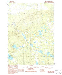
1986 Map of Kenai C-2 SE
USGS Topo · Published 1986About this map
Kenai National Wildlife Refuge and the Kenai Wilderness dominate this 1986 survey of the Kenai Peninsula, where a dense network of water bodies and marshland defines the interior geography. The landscape is characterized by a high concentration of lakes, including the elongated Bottenintnin Lake and the connected waters of Egumen Lake and Petersen Lake. These water systems are linked by the Seven Lakes River and the East Fork Moose River, providing a primary framework for navigation and wildlife habitat in this protected region. Modern infrastructure is visible through a pipeline corridor and transmission lines that bisect the wilderness, alongside established recreational sites such as the campground near Watson Lake. This map provides a precise record of the lake-studded terrain before shifting environmental patterns or increased recreational development further altered the peninsula's backcountry.
Find a feature on this map
21 named features on this map. Tap any name to fly to it.
Don’t see what you’re looking for? This feature index may not catch every label — zoom into the map to look around manually.
Map Details
Editions of this 1986 Kenai C-2 SE Map
This is the sole edition of this map. No revisions or reprints were ever made.
Other maps of this area

1944 · Kenai
USGS Topo · 1:250,000

1950 · Kenai
USGS Topo · 1:250,000

1950 · Kenai B-1
USGS Topo · 1:63,360

1951 · Kenai B-2
USGS Topo · 1:63,360

1951 · Kenai C-1
USGS Topo · 1:63,360

1951 · Kenai C-2
USGS Topo · 1:63,360

1952 · Kenai C-1
USGS Topo · 1:63,360

1952 · Kenai C-2
USGS Topo · 1:63,360

1952 · Kenai B-2
USGS Topo · 1:63,360

1952 · Kenai B-1
USGS Topo · 1:63,360