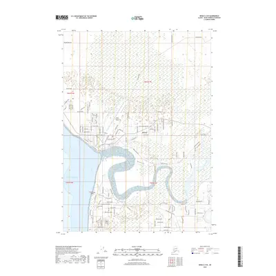
2018 Map of Kenai C-4 SE
USGS Topo · Published 2018About this map
The Kenai townsite occupies the prominent bluff overlooking the mouth of the Kenai River as it meets the Pacific Ocean. This 2018 survey detail shows the modern expansion of the settlement northward and eastward from its historical center, with a dense grid of streets including Redout Avenue and Floatplane Road. The prominent Kenai Municipal Airport dominates the central landscape, while the Kenai City Cem provides a fixed point for local genealogy and history researchers. South of the river's winding curves, the development at Kalifonsky Beach and the Doyle Estates Airport reflect the area's continued growth along the Cook Inlet coastline. The map captures the specialized transportation infrastructure of the region, from the Escape Route Road to numerous named residential streets that have defined the borough's recent decades.
Find a feature on this map
103 named features on this map. Tap any name to fly to it.
Don’t see what you’re looking for? This feature index may not catch every label — zoom into the map to look around manually.
Map Details
Editions of this 2018 Kenai C-4 SE Map
This is the sole edition of this map. No revisions or reprints were ever made.
Other maps of this area

1944 · Kenai
USGS Topo · 1:250,000

1950 · Kenai
USGS Topo · 1:250,000

1950 · Kenai C-3
USGS Topo · 1:63,360

1950 · Kenai B-3
USGS Topo · 1:63,360

1951 · Kenai C-4
USGS Topo · 1:63,360

1951 · Kenai C-3
USGS Topo · 1:63,360

1951 · Kenai B-4
USGS Topo · 1:63,360

1952 · Kenai B-3
USGS Topo · 1:63,360

1952 · Kenai C-4
USGS Topo · 1:63,360
1952 · Kenai C-3
USGS Topo · 1:63,360