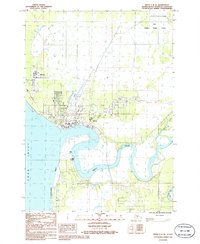
1986 Map of Kenai C-4 SE
USGS Topo · Published 1986About this map
The winding Kenai River dominates this mid-1980s look at the city of Kenai, where the river meets the Cook Inlet. The map highlights a period of significant regional infrastructure, showing the Municipal Airport and numerous Radio Towers alongside the developing road networks like Kalifornsky. The residential and commercial growth of Kenai is contrasted by the protected expanses of the Kenai National Wildlife Refuge to the northeast.
Find a feature on this map
25 named features on this map. Tap any name to fly to it.
Don’t see what you’re looking for? This feature index may not catch every label — zoom into the map to look around manually.
Map Details
Editions of this 1986 Kenai C-4 SE Map
This is the sole edition of this map. No revisions or reprints were ever made.
Other maps of this area

1944 · Kenai
USGS Topo · 1:250,000

1950 · Kenai
USGS Topo · 1:250,000

1950 · Kenai C-3
USGS Topo · 1:63,360

1950 · Kenai B-3
USGS Topo · 1:63,360

1951 · Kenai C-4
USGS Topo · 1:63,360

1951 · Kenai C-3
USGS Topo · 1:63,360

1951 · Kenai B-4
USGS Topo · 1:63,360

1952 · Kenai B-3
USGS Topo · 1:63,360

1952 · Kenai C-4
USGS Topo · 1:63,360
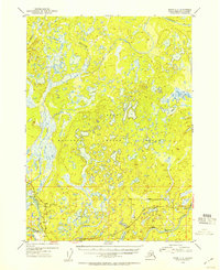
1952 · Kenai C-3
USGS Topo · 1:63,360