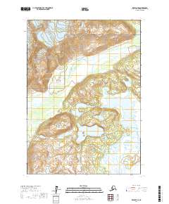
2017 Map of Kenai D-7 SE
USGS Topo · Published 2017About this map
Lake Clark National Park encompasses a significant portion of this wilderness landscape, where the hydrographic network of the Big River dominates the terrain. The map details the complex drainage of the North Fork Big River and the South Fork Big River, which converge and feed into the expansive Big River Lakes. This 2017 survey illustrates a largely roadless area characterized by significant wetland systems and the high elevation of Black Peak, providing a clear record of the glacial and alluvial patterns within the Kenai Peninsula Borough. The transition from high alpine terrain to the braided river channels and scattered lakes reflects the dynamic natural environment of the western Cook Inlet region, where the lack of established settlements emphasizes the area's role as a protected national preserve.
Find a feature on this map
11 named features on this map. Tap any name to fly to it.
Don’t see what you’re looking for? This feature index may not catch every label — zoom into the map to look around manually.
Map Details
Editions of this 2017 Kenai D-7 SE Map
This is the sole edition of this map. No revisions or reprints were ever made.
Other maps of this area

1944 · Kenai
USGS Topo · 1:250,000

1950 · Kenai
USGS Topo · 1:250,000

1958 · Kenai C-6
USGS Topo · 1:63,360

1958 · Kenai D-6
USGS Topo · 1:63,360

1958 · Kenai D-7
USGS Topo · 1:63,360

1958 · Kenai C-7
USGS Topo · 1:63,360

1958 · Kenai
USGS Topo · 1:250,000
2017 · Kenai D-7 NW
USGS Topo · 1:25,000
2017 · Kenai C-7 NE
USGS Topo · 1:25,000
2017 · Kenai C-6 NW
USGS Topo · 1:25,000