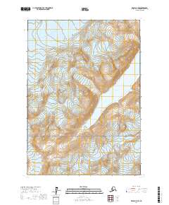
2017 Map of Kenai D-7 NW
USGS Topo · Published 2017About this map
Lake Clark National Park encompasses the southern portion of this high-altitude landscape, where the terrain is defined by the immense movement of ice and the formation of glacial waters. In the northern sections, the Blockade Glacier descends through steep contours, feeding directly into the elongated basin of Blockade Lake. This 2017 survey illustrates the stark hydrologic relationship between the glacier and the lake it sustains, showing the precise terminal point of the ice as it meets the water. The map is primarily a study of these dynamic natural boundaries, documenting the public land system across townships T9N through T11N within the Kenai Peninsula borough. Researchers interested in the evolving shoreline of glacial lakes or the specific borders of federal parkland will find the topographic detail of the surrounding peaks particularly useful for understanding the drainage patterns into the lake basin.
Find a feature on this map
9 named features on this map. Tap any name to fly to it.
Don’t see what you’re looking for? This feature index may not catch every label — zoom into the map to look around manually.
Map Details
Editions of this 2017 Kenai D-7 NW Map
This is the sole edition of this map. No revisions or reprints were ever made.
Other maps of this area

1944 · Kenai
USGS Topo · 1:250,000

1949 · Tyonek
USGS Topo · 1:250,000

1950 · Kenai
USGS Topo · 1:250,000

1951 · Tyonek
USGS Topo · 1:250,000

1958 · Kenai D-8
USGS Topo · 1:63,360

1958 · Kenai D-7
USGS Topo · 1:63,360

1958 · Tyonek
USGS Topo · 1:250,000

1958 · Tyonek A-8
USGS Topo · 1:63,360
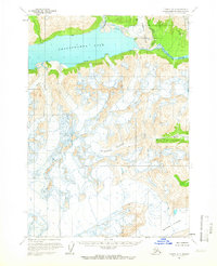
1958 · Tyonek A-7
USGS Topo · 1:63,360

1958 · Kenai
USGS Topo · 1:250,000