
1958 Map of Tyonek A-8
USGS Topo · Published 1965About this map
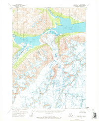
Chakachamna Lake and Kenibuna Lake dominate this glacial landscape in the late 1950s, serving as the primary drainage catchments for a complex network of ice and meltwater. The topography is defined by the massive Shamrock Glacier, which descends into the valley between these two major water bodies. Large fields of crevasses are explicitly marked across the glacial surface, indicating the active flow and dangerous terrain of the era. The hydrology of the region is fed by the Chilligan River to the north and the Neacola River and Igitna River to the west, illustrating how these waterways carve through the mountain passes. This survey, based on aerial photography from 1954 and 1957, captures the pristine state of the Alaskan interior before modern development or significant shifts in glacial extent.
Find a feature on this map
8 named features on this map. Tap any name to fly to it.
Don’t see what you’re looking for? This feature index may not catch every label — zoom into the map to look around manually.
Map Details
Editions of this 1958 Tyonek A-8 Map
2 editions found
Other maps of this area

1944 · Kenai
USGS Topo · 1:250,000

1946 · Lake Clark
USGS Topo · 1:250,000

1949 · Tyonek
USGS Topo · 1:250,000

1950 · Kenai
USGS Topo · 1:250,000

1951 · Lake Clark
USGS Topo · 1:250,000

1951 · Tyonek
USGS Topo · 1:250,000

1951 · Lime Hills
USGS Topo · 1:250,000

1958 · Tyonek B-8
USGS Topo · 1:63,360

1958 · Kenai D-8
USGS Topo · 1:63,360

1958 · Kenai D-7
USGS Topo · 1:63,360