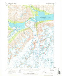
1958 Map of Tyonek A-8
USGS Topo · Published 1969About this map
Chakachamna Lake and the expansive ice of Shamrock Glacier dominate this mid-century Alaskan landscape within the Kenai Peninsula Borough. The map captures a transition point in the glacial drainage system, where the Chilligan River feeds into the main lake and a solitary Cabin sits near the river mouth, indicating a rare point of human presence in this high-elevation terrain. To the west, Kenibuna Lake is fed by the Neacola River and Igitna River, creating a complex network of glacial meltwater. The topographic survey provides precise detail on the Crevasses and ice movements of the glacier as it pushes toward Shamrock Lake, offering a scientific record of the area's geography before later decades of environmental change.
Find a feature on this map
10 named features on this map. Tap any name to fly to it.
Don’t see what you’re looking for? This feature index may not catch every label — zoom into the map to look around manually.
Map Details
Editions of this 1958 Tyonek A-8 Map
2 editions found

Other maps of this area

1944 · Kenai
USGS Topo · 1:250,000

1946 · Lake Clark
USGS Topo · 1:250,000

1949 · Tyonek
USGS Topo · 1:250,000

1950 · Kenai
USGS Topo · 1:250,000

1951 · Lake Clark
USGS Topo · 1:250,000

1951 · Tyonek
USGS Topo · 1:250,000

1951 · Lime Hills
USGS Topo · 1:250,000

1958 · Tyonek B-8
USGS Topo · 1:63,360

1958 · Kenai D-8
USGS Topo · 1:63,360

1958 · Kenai D-7
USGS Topo · 1:63,360