
1958 Map of Kenai D-8
USGS Topo · Published 1963About this map
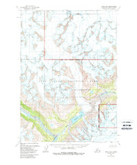
Lake Clark Pass serves as the central focal point of this late 1950s survey, marking a significant natural corridor through the high mountain terrain. The hydrologic divide is clearly visible where the Tlikakila River flows to the southwest from the vicinity of Summit Lake, while drainage to the northeast is dominated by the North Fork Big River. The landscape is characterized by extensive glacial systems, including the Alto Glacier and several unnamed ice fields marked by numerous crevasses. Mapped primarily through photogrammetric methods from aerial photography, this document records a wilderness state prior to any established road or trail development, focusing instead on the raw topography of the Seward Meridian and the complex intersection of alpine peaks and ice-carved valleys.
Find a feature on this map
8 named features on this map. Tap any name to fly to it.
Don’t see what you’re looking for? This feature index may not catch every label — zoom into the map to look around manually.
Map Details
Editions of this 1958 Kenai D-8 Map
2 editions found
Other maps of this area

1944 · Kenai
USGS Topo · 1:250,000

1946 · Lake Clark
USGS Topo · 1:250,000

1949 · Tyonek
USGS Topo · 1:250,000

1950 · Kenai
USGS Topo · 1:250,000

1951 · Lake Clark
USGS Topo · 1:250,000

1951 · Tyonek
USGS Topo · 1:250,000

1951 · Lime Hills
USGS Topo · 1:250,000

1958 · Kenai C-8
USGS Topo · 1:63,360

1958 · Kenai D-7
USGS Topo · 1:63,360

1958 · Kenai C-7
USGS Topo · 1:63,360