1944 Map of Kenai
USGS Topo · Published 1954About this map
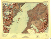
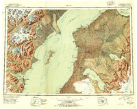
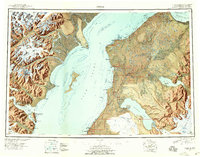
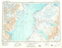
Cook Inlet dominates this mid-century survey, dividing the towering peaks of the Alaska Range from the burgeoning communities of the Kenai Peninsula. On the eastern shore, the Sterling Highway establishes a corridor for development, connecting established settlements like Kenai and Ninilchik while passing near the Salamatof (Abandoned) site. The inland geography is defined by the Kenai National Moose Range, a landscape of interconnected water bodies such as Skilak Lake and Tustumena Lake fed by glacial runoff. To the west, across the inlet, the terrain rises sharply toward Redoubt Volcano and Double Peak, where the industrial presence is limited to outposts like Snug Harbor Cannery on Chisik Island. This compilation reflects a transitional era for the region, balancing the preservation of wildlands with the early infrastructure of the Third Judicial Division.
Find a feature on this map
84 named features on this map. Tap any name to fly to it.
Don’t see what you’re looking for? This feature index may not catch every label — zoom into the map to look around manually.
Map Details
Editions of this 1944 Kenai Map
4 editions found

Historical Maps of Kenai Through Time
3 maps found