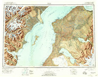
1944 Map of Kenai
USGS Topo · Published 1958About this map
Cook Inlet dominates this mid-century survey, dividing the dramatic volcanic peaks of the west from the developing settlements of the Kenai Peninsula. On the eastern shore, the transition from traditional outposts to modern infrastructure is visible as the Sterling Highway begins to connect communities like Soldotna, Kasilof, and Ninilchik. The map documents a specific moment in the region's geography, noting Salamatof as an abandoned site while highlighting the establishment of the Kenai Moose Range and the Tuxedni National Wildlife Refuge. Across the inlet, the landscape is defined by massive glacial systems including the Red Glacier and the towering Redoubt Volcano. Traces of the local maritime economy appear at the Harbor Cannery near Iliamna Pt, while inland, the complex hydrology of Tustumena Lake and the Kenai River illustrates the importance of these waterways for early transport and subsistence.
Find a feature on this map
97 named features on this map. Tap any name to fly to it.
Don’t see what you’re looking for? This feature index may not catch every label — zoom into the map to look around manually.
Map Details
Editions of this 1944 Kenai Map
4 editions found
Other maps of this area

1944 · Kenai
USGS Topo · 1:250,000

1946 · Blying Sound
USGS Topo · 1:250,000

1946 · Lake Clark
USGS Topo · 1:250,000

1946 · Seldovia D-5
USGS Topo · 1:63,360

1949 · Tyonek
USGS Topo · 1:250,000

1949 · Seldovia D-4
USGS Topo · 1:63,360

1950 · Kenai
USGS Topo · 1:250,000

1950 · Kenai C-3
USGS Topo · 1:63,360

1950 · Kenai B-1
USGS Topo · 1:63,360

1950 · Seldovia D-2
USGS Topo · 1:63,360