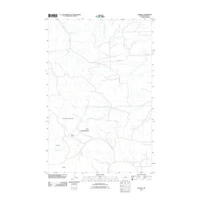
2011 Map of Kendall
USGS Topo · Published 2011About this map
Kendall is the focal point of this Fergus County landscape, marking the site of a once-active mining settlement within the North Moccasin Mountains. The terrain transitions from the elevated heights of the mountains down into rugged drainages like Mason Canyon and JT Canyon. For those tracing local history, the Kendall Cemetery remains a tangible link to the community that formerly occupied this area. The drainage pattern is complex, with Little Dog Creek, Dog Creek, and Last Chance Creek cutting through the foothills. Regional access is defined by unpaved corridors such as Salt Creek Rd and N Kendall Rd, which connect the historical townsite to the surrounding prairie. This area, located just north of the Judith Mountains, illustrates a typical Montana mining district where the town has faded while the natural landmarks and geographic names endure.
Find a feature on this map
23 named features on this map. Tap any name to fly to it.
Don’t see what you’re looking for? This feature index may not catch every label — zoom into the map to look around manually.
Map Details
Editions of this 2011 Kendall Map
This is the sole edition of this map. No revisions or reprints were ever made.
Other maps of this area

1941 · Lewistown
USGS Topo · 1:62,500

1944 · Lewistown
USGS Topo · 1:62,500

1954 · Lewistown
USGS Topo · 1:250,000

1959 · Lewistown
USGS Topo · 1:250,000

1970 · Spring Creek Junction
USGS Topo · 1:24,000

1978 · Seventytwo Hills
USGS Topo · 1:24,000

1978 · Wild Bill Flat East
USGS Topo · 1:24,000

1978 · Lewistown
USGS Topo · 1:100,000
1985 · Hilger NW
USGS Topo · 1:24,000
1985 · Kendall
USGS Topo · 1:24,000