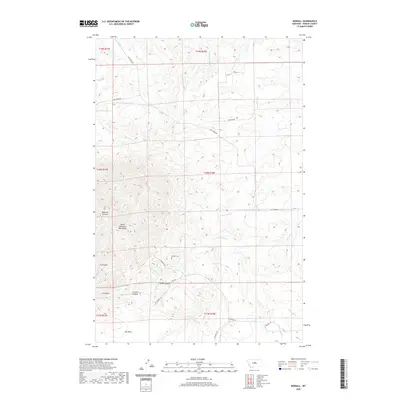
2020 Map of Kendall
USGS Topo · Published 2020About this map
The North Moccasin Mountains dominate the western landscape of this Fergus County region, where steep drainage patterns have carved a series of distinctive landforms. Deep cuts like Bedrock Canyon, Iron Gulch, and Mason Canyon define the transition from the high peaks down toward the plains. This area maintains a strong connection to its early development through sites like Kendall Cem, a vital point of interest for those tracing local family lineages in this remote Montana stretch.
Find a feature on this map
34 named features on this map. Tap any name to fly to it.
Don’t see what you’re looking for? This feature index may not catch every label — zoom into the map to look around manually.
Map Details
Editions of this 2020 Kendall Map
This is the sole edition of this map. No revisions or reprints were ever made.
Other maps of this area

1941 · Lewistown
USGS Topo · 1:62,500

1944 · Lewistown
USGS Topo · 1:62,500

1954 · Lewistown
USGS Topo · 1:250,000

1959 · Lewistown
USGS Topo · 1:250,000

1970 · Spring Creek Junction
USGS Topo · 1:24,000

1978 · Seventytwo Hills
USGS Topo · 1:24,000

1978 · Wild Bill Flat East
USGS Topo · 1:24,000

1978 · Lewistown
USGS Topo · 1:100,000
1985 · Hilger NW
USGS Topo · 1:24,000
1985 · Kendall
USGS Topo · 1:24,000