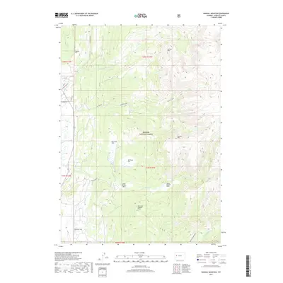
2017 Map of Kendall Mountain
USGS Topo · Published 2017About this map
Kendall Mtn and Saltlick Mtn dominate this high-altitude landscape within the Bridger National Forest, where the complex drainage systems of the Wind River Range define the geography. The map illustrates a high-country network of alpine basins and creek valleys, notably Upper Boulder Basin and Lower Boulder Basin, which feed into Boulder Cr. For the local historian or outdoorsman, the map reveals a series of designated meadows and flats such as Pot Creek Park, Kim Rush Park, and the expansive McDowell Flat. This area is accessed by rugged forest routes including Boulder Basin Rd and Gypsum Creek Rd, which provide passage to remote locations like Jim Cr Lake and the New Fork Lookout Point. The presence of the New Fork River in the southeast corner marks the beginning of the major watershed that drains these mountain slopes.
Find a feature on this map
36 named features on this map. Tap any name to fly to it.
Don’t see what you’re looking for? This feature index may not catch every label — zoom into the map to look around manually.
Map Details
Editions of this 2017 Kendall Mountain Map
This is the sole edition of this map. No revisions or reprints were ever made.
Other maps of this area

1907 · Gros Ventre
USGS Topo · 1:125,000

1909 · Fremont Peak
USGS Topo · 1:125,000

1910 · Gros Ventre
USGS Topo · 1:125,000

1955 · Driggs
USGS Topo · 1:250,000

1955 · Thermopolis
USGS Topo · 1:250,000

1958 · Driggs
USGS Topo · 1:250,000

1958 · Thermopolis
USGS Topo · 1:250,000

1962 · Thermopolis
USGS Topo · 1:250,000

1962 · Driggs
USGS Topo · 1:250,000
1966 · Warren Bridge
USGS Topo · 1:24,000